Friday, July 26, 2013

Sharing the Landscape with the Caribou for Ten Days

So here's what I sent to the SCA for my final blog post of my stint of syndication with their blog website. Next post will be all me and only available here!

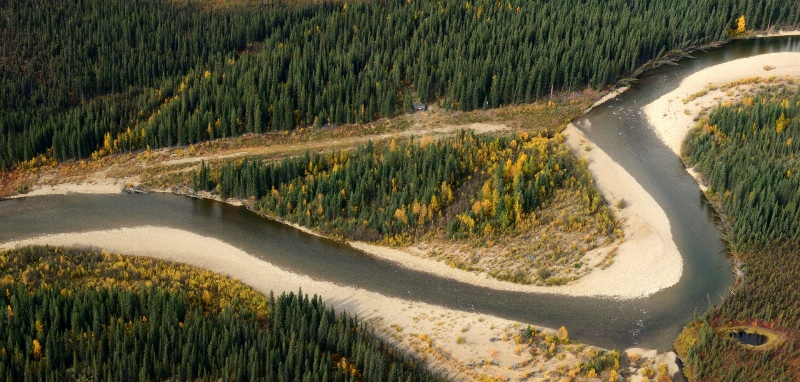
Nothing can inspire a person to conserve the earth’s beauty more than spending time in wilderness. Josh, my supervisor, and I, just returned from a ten-day off-trail backpacking trip through the upland wilderness of Yukon-Charley Rivers National Preserve in eastern Interior Alaska. We traveled by bush plane, landing on tall grass in an area near Copper Mountain and the upper Charley River. It was an amazing experience; we shared the landscape with the caribou, the wolverines, the marmots, and the bears (although we saw none; not even tracks or scat). And, we brought cameras. The sole purpose of our trip was to visually document the area so that others can be inspired to come and enjoy and respect the landscape.

Itty-bitty plane.
We landed in a Helio Super Courier on a relatively smooth bush airstrip in a lowland field. Immediately surrounding the strip on all sides is ferocious wetland, filled with tussocks, moss, and watery, squelchy ground. Note to anyone traveling off-trail in Alaska; try to travel with a light pack so that you can wear lighter shoes, such as trailrunners, that dry quickly. Even if you wear the top-of-the-line Gore-Tex backpacking boots, your feet will still get soaked, so you might as well give up on trying to keep your feet dry and instead wear shoes that dry quickly. You’ll also travel faster and easier with more lightweight shoes and equipment. Nowhere else other than in Alaska is this so important.

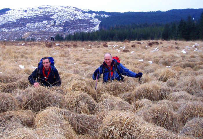
Can you say wet feet?
We slogged through the tussocks up to higher ground, where the water drains well enough to allow spruce trees and brush such as dwarf birch to grow in dense thickets. Wear long sleeves and gaiters in these sections, or your arms will be scratched and your pants will be ripped! As elevation increases, however, the trees and brush reduce in size significantly until they are no longer present.

Josh shootin' away.
We had had our heads forward for so long, sweating and slogging through thick brush uphill, yelling “Yogi!” profusely to notify any bears that might be in the area that we were passing through, that we hadn’t looked back behind us for a while. When we did, we saw the beautiful basin that we had left.

I added in the red lines so you can see where the airstrip is.
We noticed that the airstrip, which is about 800 feet long, looked like a tiny speck compared to the rest of the landscape. It’s amazing how small we began to feel after being immersed in a wilderness like Yukon-Charley. Humans can’t even hike over tussocks without occasionally breaking our ankles, but wolverines hop around like Michael Johnson among toddlers.

There is probably enough poison in the purple flowers, monkshood, in this picture to kill half of the population of Fairbanks. Be careful where you camp, and DON'T EAT THESE.
Once we were above the tree line, the landscape moved to grasses and flowers in the wetter areas and low moss, rock, and berry plants in the drier areas. Sadly, we were a few weeks too early for berry season; we only found about three blueberries that were ripe enough to eat.

Copper is the highest peak you see in the photo.
For the first two nights, we camped under the shadow of Copper Mountain, 6367’, our hiking objective for the trip. It’s quite a rugged mountain above 5500’, with sheer scree slopes littered with huge, loose rocks and boulders. We were not aware of this level of ruggedness, however, and we realized at about 6000’ that we had taken the wrong direction of approach. Another mossy buttress other than the one we took would have been a much better (and safer) choice. The risk of the route we had chosen was too great. Next time! However, the fact that not even we, the National Park Service, had been aware of the level of ruggedness of the second highest peak in the preserve, goes to show the deep level of wilderness that abounds in Alaska. Alaska’s wilderness areas are absolutely untouched compared to “wilderness” areas in the contiguous United States.

Here's a closer view of Copper. We tried to hike along that ridge in the back on the left. It didn't work. We should have dipped down into the valley over the close ridge and come up the big, wide mossy slope that faces the camera.
As we hiked up the ridge on our summit attempt, we had a few encounters with bull caribou. They made experienced hikers like us look like crawling babies what with their ability to prance around on mossy and rocky ridgeline slopes. Throughout the trip, we saw around five caribou on the ground, as well as an entire herd of at least fifty on the flight out of the preserve. The nice thing about seeing lots of caribou is that their presence precludes that of bears for a few hours!

Bull caribou wondering what the hell we are since it's probably never seen a human before.
We spotted two Dall sheep on a ridge across the valley towards Copper Mountain, and we heard an enormous amount of marmots and pika squeaking with disapproval at our presence on the alpine rocky slopes. Listen to the marmots; their squealing calls may be letting you know of the presence of an unwelcome creature (a bear) near your camp.

The icing on the wildlife cake, however, was the sighting of two wolverines on two consecutive days near the end of the trip. Most wilderness travelers go their entire lives without seeing a single wolverine, and we saw two. The Athabaskans, the natives of Interior Alaska, consider the wolverine their chief animal for its strength, agility, speed, and ability to inspire fear in all other animals, despite its small size. Seeing the wolverines, although only for a few seconds each, was an amazing experience. Josh even got video of the first one that should be up on the Yukon-Charley Rivers website soon.

Yeah, I know, it was a pretty terrible place to be. I hated it too.
After we made the call to abandon the summit attempt of Copper Mountain, we descended over the other side of the ridge into a picturesque high alpine valley, complete with crystal-clear snowmelt-fed lakes and streams. It was the most captivating place that I have ever spent time in. Unfortunately, it rained for at least three of the four days that we spent there; we were still able to get some good shots, however. We were sad to leave when it came time to hike back to the airstrip.

Josh, the ultralighter, and his pack.
After having eaten four more days of food, our packs were significantly lighter heading back up the ridge than they had been coming down it. We backtracked our previous path relatively quickly, making our way back to the airstrip in two days. We had set up camp at the airstrip the night before our pickup date when we heard the hum of a plane propeller. We looked up in the sky out of our shelter, and circling the airstrip was a small bush plane, but not the one that was to come pick us up! We quickly removed our tent from the middle of the airstrip and let the plane land. A local bush pilot, Dave, was simply resting at the strip for the night before continuing on to get some more fuel. Early the next morning, he took off, and I shot a video of his takeoff. Enjoy!


It wasn’t long after Dave took off that we did, as well. As we flew low and weaved through the mountains on the flight out of the preserve, I was looking forward to some fresh food, but I was also sad to leave such a pristine wilderness. It’s a place for reflection, and it’s a reminder that, without technology, humans are simply inferior to the other wildlife. Hopefully my images can convey that sentiment. Thanks for reading.

Monday, July 15, 2013

Leaving for the backpacking trip of a lifetime.

How many other times in my life will I have the funding or logistical ability to charter a bush plane to land me on a gravel bar near the headwaters of a river in remote Interior Alaska? I can probably count those on one hand, if they exist at all.

Tomorrow morning, my boss/coworker/friend Josh and I will be flown by a bush pilot in a small plane passenger-bearing mosquito that can do short takeoffs and landings (STOL) on unimproved terrain, like ridgelines, meadows, or, in this case, gravel bars. This is a shot Josh took last year of the "airstrip" that we'll be picked up at (hopefully) at the end of our trip.

We'll be hiking for ten days, and the route is easy, only about 45 miles. We can take it slowly, which is good, since the goal of the trip is to photograph the alpine areas above the Upper Charley River. Pretty cool that the whole point of all this is just to make photographs, right? I love my job.

So here is all of the gear and food that I take with me out of my house tomorrow morning. Not all of it will actually be taken on my back and carried the whole time.


This is what everything looks like when it's all packed. The clear bag with the lime green bottom and the the red duct tape around it is a dry bag that has my camera and its gear inside of it. I'll have the bag in my lap on the plane, and then the camera will be on a strap around my neck while hiking. The boots I'll be wearing (obviously), and the clothes on the ground are cotton clothes to wear underneath my flight suit on the plane. The green bag has my flight suit, flight helmet, flight gloves, and a Stat Pack (emergency survival kit in case the plane crashes in the middle of nowhere and I survive and have to figure out how to get back to civilization; knock on wood, pray, or hope, please, whatever your fancy). The cotton clothes and the flight bag will go back with the pilot once we land, and it will return on the plane on the day we're picked up so I can use it again on the flight back. When we land, I have some (no, a lot) of clothes (hiking socks, synthetic underwear, gaiters, hiking pants, belt, bug shirt, hat, sunglasses) that I'll put on that currently reside in the backpack, so it will get a little bit less bulky. It's also like, half food. So, eating a lot will make the size go down a lot, too. By the end of the trip, it will be so easy to pack my bag, especially since we're carrying a full ten days of food. That's a lot of food.


I don't know how much my pack weighs, but it probably weighs more than Josh's, which weighs 33 pounds. My best guess as to my pack weight would be 40-45 pounds, up to 20 of which could be food. Josh is bringing 15 pounds of food; I think mine is a little less calorically dense, so mine is probably around 17 or 18 pounds. Either way, at the end of the trip, we'll be practically running. For like, two hours each day, since we only have to average 4.5 miles per day. Josh, an ultralight queen fanatic/enthusiast (if you're reading this, hi), would probably faint at my pack weight. I should be fainting at it right now, but I think the reason I'm not is that I haven't hiked through tussocks with it on yet. Then I'll faint just by thinking about the weight. Guess I'll just have to eat the food!

I'm extremely excited about this trip; it could end up being the coolest trip I've gone on so far. Really excited. Pics and a post on this trip to come, probably in mid-August if not in late July, since I have another trip about five days after the end of this one, hiking and maybe packrafting the lower section of the Charley River. Thanks for reading!

Appendix: If anyone is interested, here is my gear list. Josh is bringing some group gear too, so this list is not exhaustive:

CONTAINMENT:
Backpack
Extra hip belt clip
P-cord
Pack cover
Trash bag to line bag

CLOTHING:
Boots
Gaiters
Three pairs hiking socks
One pair sleep socks
Long underwear pants
Long underwear top
2 pairs underwear
Base layer shirt
Bug shirt
Light synthetic jacket
Fleece gloves
Bug gloves
Head net
Hat
Rain shell pants
Sunglasses with croakies
Warm hat
Hiking pants
Belt
Puff jacket
Rain shell jacket

SHELTER AND SLEEP SYSTEM:
Tent
Pole
Ground cloth
Sleeping bag
Sleeping pad
Pillow

FOOD AND EATING ACCESSORIES:
OPSAKs
2 Red Couch sandwiches
Oatmeal
Snickers
Pop-Tarts
Jerky
Fritos
GORP
Triscuits
Almond butter (2 jars)
Bars
Fruit leathers
Ten dinners with meats
Olive oil
Hot tea
Drink mix
2 bike bottles
Platypus bladder with 2 caps
Thermal rehydration cozy for dinners

TOILETRIES:
Biodegradable toilet paper
Toothbrush
Toothpaste
Sunscreen
Chapstick
Hand sanitizer
Contact solution
Contact case
Rewetting drops
Contacts
Glasses with case
Allergy pills and nose spray
Thermometer
2 bandannas
Sporknife
Quart-size Ziploc for lunches
2.5 gallon-size Ziploc for trash
Bear spray

CAMERA EQUIPMENT:
Dry bag for camera
Camera
Lens
Batteries
Memory cards
Lens cleaner

CAMP EQUIPMENT:
Book
Knife
Headlamp

FLIGHT EQUIPMENT:
Flight bag
Flight suit
Flight helmet
Flight gloves
STAT pack
Cotton pants
Cotton shirt
Cotton underwear
Cotton socks

Wednesday, July 10, 2013

Yukon River boating

On my second patrol, June 18th-26th, my supervisor, Josh, and I embarked on a motorboat trip up and down the section of the Yukon River that lies within Yukon-Charley Rivers National Preserve. Our objective was pretty much all-encompassing: we were to snap pictures of nearly everything of interest on the river. We were to get snapshots for everything from websites to brochures to art to simple internal documentation. Endemic flower species, rocky bluffs lining the riverbanks, vegetation, mosquitoes, scenic views, historical artifacts, fossils, public-use cabins, gold rush relics, and more. It was an epic trip. We boated over 800 miles in nine days, worked over a hundred hours, saw seven grizzly bears and four moose, and got completely coated in glacial silt from the river. I think there’s still some silt in one of my lenses’ focusing ring. The Yukon is an enormous, powerful river that inspires reverence in everyone who travels along it. It truly is an experience that must be had to explain.


On the first day, we took off downriver in a government boat from the preserve headquarters town, Eagle. We were to cover 100 miles in the first day, which takes about four hours on the boat without stopping—we took six hours, since we stopped occasionally to cut the boat’s motor and shoot items of interest.


As of last September, one of the first items of interest that one encounters while going downriver on the Yukon from Eagle is the Windfall Mountain “Fire”. In September 2012, Eagle residents heard a loud boom and felt a small tremor. In winter, preserve personnel went on an exploratory flight to look for what might have happened, when they encountered a collapsed ridgeline, flames, and smoke.


No one’s sure what happened, but the theory is that there is a shale oil or coal deposit of some kind that exploded and is now burning off. The ridgeline completely collapsed and remains unstable; more and more of it occasionally falls in. The last time I was in Eagle, I saw the US Geological Survey out there checking the site, so we may know exactly what happened sometime soon.


Further downriver, around fifty miles from Eagle by boat, near the Charley River’s confluence into the Yukon, the river traveler encounters a view of the uplands of the preserve and the mountains that line the Charley as it flows north. It’s an absolutely beautiful section of the river, and it’s rich with natural history such as geological structures, fossils, and rare plant species—as well as grizzly bears! We saw a sow and her two cubs on a bluff near water level as we rounded one turn; the three of them immediately bolted into the brush as soon as they saw us. It was nice to have my first wild bear sighting occur while I was inside of a speedy motorboat!


Further downriver, near the end of the preserve boundary, the river is rich with geological material. Each bluff’s structure is unique, and they all exude the sense of being walled into the river, as if the river wants its travelers to float all the way west, across the entire state, to the Bering Sea.


We arrived in the evening at Slaven’s Roadhouse, a nearly 100-year-old two-story public-use cabin located on the river left bank of the Yukon River about 100 miles downriver from Eagle. One of the preserve’s interpretive rangers, Randy, was stationed there, as is the norm during summer when the river sees a high number of visitors enjoying a float trip. We stayed the night at the roadhouse for probably half the nights during the trip; the roadhouse is a good jump-off point for most river excursions, and we had the luxury of a motorboat, which allowed us to speedily travel both upriver and downriver.


There’s an ATV trail leading from the roadhouse to an old gold mining camp five miles away, except during our stay the trail was blocked by damming beavers at a creek crossing! They were fine with us watching them build, however.


The camp supported the Coal Creek Dredge, a historic gold mining dredge in operation from the 1930’s through the 1970’s in the preserve. Huge mounds of gravel that the dredge chewed up, sucked the gold out of, and spat out line the Coal Creek drainage area.


The entire Coal Creek drainage is littered with all manner of gorgeous, colorful wildflowers in summer. They are usually teeming with bees, who are so happy at the pollen harvest that they don’t usually notice humans—the mosquito is the more troublesome flying insect in Interior Alaska. If you don’t believe me, just check out this video I took of Josh trying to shoot a flower while being attacked by them.

I am absolutely amazed at the grandiosity and variety of life and structure that is present in the Yukon River corridor. It’s my hope that my images will spur people on to come to the area to enjoy and protect this rich environment; it’s worth seeing, and it’s worth keeping, for sure.

Tuesday, July 9, 2013

The First Patrol

Okay, so I know, I've been REALLY behind on this. It's been over a month since I last posted. But, the reason is, this is only the fourth day I've actually worked in the Fairbanks office since June 5th. So I've barely had time to look at pictures, much less edit them; I've been in the field so much that I get lots of time off when I come home, and then when I go back to work, it's already time to plan for the next patrol! It's been nice to have the time off, though. I get to relax, sleep in since I don't get much sleep on patrols, and this past week my parents flew up from Dallas and we went down to Denali. It was pretty cool. Anyway, so I figured it would be a good idea to, you know, tell you a little bit about my first day of real, actual work. So, here goes.

From June 6th-12th, I was stationed out of the Yukon-Charley Rivers National Preserve headquarters in Eagle, Alaska. I did and photographed a lot of things during that short time, but by far the highlight of the trip was the three-day stint I spent with the preserve’s archaeology crew.


The crew was in the middle of their annual two-week helicopter survey. For fifteen days straight, they flew out each day, landing on unimproved sites that are only accessible by helicopter, such as flat ridges and gentle slopes vegetated primarily with dry, mossy tundra. While at these sites, they slowly walked around the tundra, keeping an eye out for stone tools and flakes that would have been used by ancient Alaska Native hunters while hunting caribou. The main goal was to learn more about the migration patterns and lifestyles that the natives had in the preserve in an effort to learn more about Interior Alaska before Western contact. You can learn more about the archaeologists’ work in the preserve here.


On the second, and arguably most exciting, day that I was part of the group, we landed on a gorgeous alpine ridge. Moss, grassy vegetation, and rock coated the terrain; it was a hiker’s dream. The sun blazed, helping with the upland chill; the wind howled, keeping the mosquitoes at bay; and sweeping views abounded. I did some of the best hiking I’ve ever done on that day. When we landed, the archaeologists broke out their GPS device and planned out the day’s route. It’s important for them to search in areas near where they’ve found artifacts before in order to increase the likelihood of finding something—but not so close that they’re encroaching on or just re-encountering their previous findings. They rely heavily on accurate GPS technology in their fieldwork.


We hiked all morning with no luck. But, no one complained, probably because of the beautiful location. I can’t imagine a better-looking workplace than the upper Seventymile River drainage. We stopped to eat our sandwiches while still near the landing site, but, after lunch, we proceeded downhill. We were pretty spread out while hiking down the hill; I was in the back so I could focus on shooting the scenery, because there wasn’t really anything interesting to shoot while the archaeologists were just hiking. The lead hiker was about half a mile ahead of me, and when he reached a rocky bench about midway down the hill, he gave a loud shout. He had found an enormous cluster of tool remnants lying on the top layer of the tundra. The other surveyors and I hurried down the hill and immediately hopped to work.


The surveyors picked out stone tool remnants like M&M’s on carpet, planting flags by each artifact they found, making waypoint markers on the GPS, and taking notes about the site. It was extremely interesting to watch them do their survey, and I knew I was doing an important job by documenting their oft-overlooked work.


After the crew thought they had given the site a thorough visual scouring, they performed what they call a “shovel test”: they dug about eight inches down in about two inch increments, stopping at each increment to sift through the dirt to see if any artifacts might have been covered over by soil. They explained that the shovel test is a type of test that is generally more effective and necessary in rainier areas of the lower 48; in the Alaskan tundra, it was more of a formality, since most artifacts lying on dry tundra will not be disturbed by weather, even over thousands of years.


Most of the artifacts found at that site in particular were flint rock that had obviously been “napped,” or chipped and shaped into a blade useful for cutting. It seems that areas like the one we found on that day were popular sites for the ancient Athabaskan Alaska Natives to watch for caribou during a hunt or to process their meat after a successful kill. The evidence of these actions is literally lying out in the open on the upland tundra of the Charley River basin, waiting for archaeology crews (or hikers and hunters) to find it and to tell the stories of the ancient dwellers of the mountains. I had a wonderful and enlightening three days with the crew; I learned a great deal about the rich cultural and archaeological history in the preserve, and the new knowledge further inspired me to accurately and artfully portray the preserve through my photographs in such a way that would inspire others to conserve it.

Up next – a highlight from my second patrol, a motorboat trip on the Yukon River!